
Corfe Common - Walking Guide

Explore the Trails
CORFE COMMON
Whatever it is, the way you tell your story online can make all the difference.
Walking guide: Corfe Common History walk
The Corfe Common History Walk is a delightful route that combines scenic beauty with rich historical insights. You’ll enjoy panoramic views of Corfe Castle & the surrounding Purbeck Hills. The landscape is dotted with wildflowers & offers opportunities for wildlife spotting. The walk is an excellent way to appreciate the natural landscape & the historical context of the area, making it the perfect outing.

Walking
Dogs on leads welcome A mildly challenging walk with a moderate climb in the middle. Mostly level surfaces with some are kissing gates.
F OS map: SY961821
Trail Route
START POINT
Mortons Manor
STEP 1
From Mortons Manor, come out of the hotel and hear towards the village. Once in the village square, walk along West Street, once the main street through the village. It was known as Duck Street due to the number of animals driven along it onto the common and the mess they left behind.
STEP 2
Turn right towards West Street car park. At the end of the car park turn right again through a kissing gate. Once through the gate, turn left and follow a path along the edge of the field. This is the Halves or Haws, communal land once used for strip and furrow farming. Families would each have had a strip on which to grow their own food, much like allotments.
STEP 3
Go through the stone kissing gate and stop at Copper Bridge. Built in the 1800s, this small humpback bridge used to be on the main road to Church Knowle. Animals would have walked through the ford at the side of the bridge.
STEP 4
Turn left up the slope (almost going back on yourself) and follow the hedge. When you get to the top of the slope bear right at the cattle grid to join the unclassified road.
STEP 5
Follow the road down the dip and up the other side. At the top, leave the road and follow the path left to the top of the ridge. In the 18th century, smugglers carried contraband such as fine French brandy and ladies' silk gloves across the common on their way from the Purbeck coast to London. Some villagers still have common rights and graze their cows or horses on the common for an annual fee. Each year a Hayward (someone who, in the Middle Ages, oversaw the harvesting of crops) is appointed to collect the fee and to make sure the animals are well cared for.
STEP 6
Along the ridge you'll find a series of low humps. These are the remains of 4,000-year-old Bronze Age burial mounds. From here you can enjoy views of the Castle to the north and the village of Kingston to the south.
STEP 7
Turn left at the large, low burial mound at the end of the ridge and make your way to the bottom of the slope walking down the hollow ways towards the lower common. They are all that remain of old tracks which led from the quarries to Corfe Castle. Over time, carts laden with limestone wore away the track and it became a deep muddy gully. When it became impassable they just moved to the side and started a new track.
STEP 8
Follow the path towards the gate at the top corner of the common, along the path between the houses and onto Middle Halves. Signposts then mark the way back to Corfe Castle.
End Point
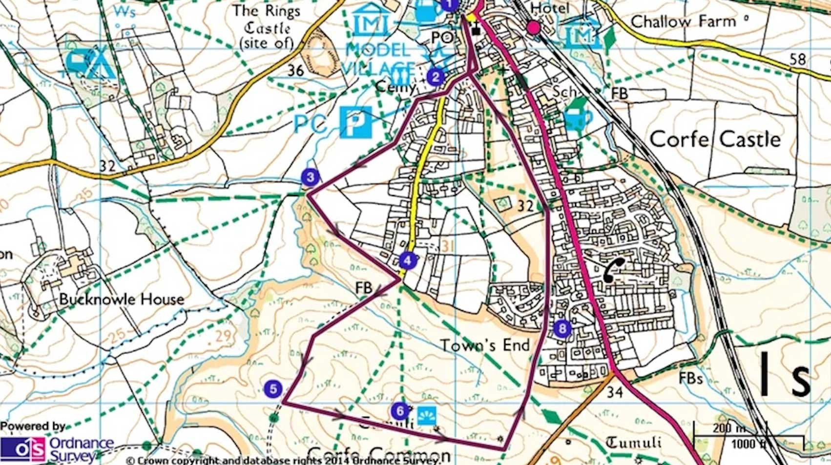
A map of the Corfe Common walk | © Crown copyright and database rights 2013 Ordnance Survey
Getting Here
Address
Mortons Manor, Corfe Castle, Dorset. BH20 5EE
By train
Wareham, 4.5 miles (7.2km). Corfe Castle station (Swanage Steam Railway) is a few minutes’ walk away
By Bus
Wiltshire and Dorset 40, Poole to Swanage (passing Wareham station).
By road
The A351, Wareham to Swanage, runs through Corfe Castle village.